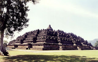
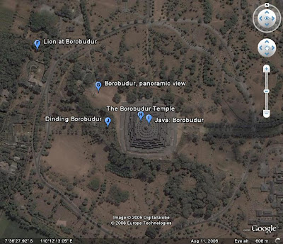
Borobudur is a ninth-century Mahayana Buddhist monument in Magelang, Central Java, Indonesia. The monument comprises six square platforms topped by three circular platforms, and is decorated with 2,672 relief panels and 504 Buddha statues. A main dome, located at the center of the top platform, is surrounded by 72 Buddha statues seated inside perforated stupa.
The monument is both a shrine to the Lord Buddha and a place for Buddhist pilgrimage. The journey for pilgrims begins at the base of the monument and follows a path circumambulating the monument while ascending to the top through the three levels of Buddhist cosmology, namely Kāmadhātu (the world of desire), Rupadhatu (the world of forms) and Arupadhatu (the world of formlessness). During the journey the monument guides the pilgrims through a system of stairways and corridors with 1,460 narrative relief panels on the wall and the balustrades.
Evidence suggests Borobudur was abandoned following the fourteenth century decline of Buddhist and Hindu kingdoms in Java, and the Javanese conversion to Islam. Worldwide knowledge of its existence was sparked in 1814 by Sir Thomas Stamford Raffles, the then British ruler of Java, who was advised of its location by native Indonesians. Borobudur has since been preserved through several restorations. The largest restoration project was undertaken between 1975 and 1982 by the Indonesian government and UNESCO, following which the monument was listed as a UNESCO World Heritage Site. Borobudur is still used for pilgrimage; once a year Buddhists in Indonesia celebrate Vesak at the monument, and Borobudur is Indonesia's single most visited tourist attraction.
Etymology
 In Indonesian, ancient temples are known as candi; thus "Borobudur Temple" is locally known as Candi Borobudur. The term candi is also used more loosely to describe any ancient structure, for example gates and bathing structures. The origins of the name Borobudur however are unclear, although the original names of most ancient Indonesian temples are no longer known. The name Borobudur was first written in Sir Thomas Raffles' book on Javan history. Raffles wrote about a monument called borobudur, but there are no older documents suggesting the same name.The only old Javanese manuscript that hints at the monument as a holy Buddhist sanctuary is Nagarakretagama, written by Mpu Prapanca in 1365.
The name 'Bore-Budur', and thus 'BoroBudur', is thought to have been written by Raffles in English grammar to mean the nearby village of Bore; most candi are named after a nearby village. If it followed Javanese language, the monument should have been named 'BudurBoro'. Raffles also suggested that 'Budur' might correspond to the modern Javanese word Buda ('ancient') – i.e., 'ancient Boro'. However, another archaeologist suggests the second component of the name ('Budur') comes from Javanese term bhudhara (or mountain).
Location
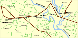
Approximately 40 kilometers (25 mi) northwest of Yogyakarta, Borobudur is located in an elevated area between two twin volcanoes, Sundoro-Sumbing and Merbabu-Merapi, and two rivers, the Progo and the Elo. According to local myth, the area known as Kedu Plain is a Javanese 'sacred' place and has been dubbed 'the garden of Java' due to its high agricultural fertility. Besides Borobudur, there are other Buddhist and Hindu temples in the area, including the Prambanan temples compound. During the restoration in the early 1900s, it was discovered that three Buddhist temples in the region, Borobudur, Pawon and Mendut, are lined in one straight line position. It might be accidental, but the temples' alignment is in conjunction with a native folk tale that a long time ago, there was a brick-paved road from Borobudur to Mendut with walls on both sides. The three temples (Borobudur–Pawon–Mendut) have similar architecture and ornamentation derived from the same time period, which suggests that ritual relationship between the three temples, in order to have formed a sacred unity, must have existed, although exact ritual process is yet unknown.
Unlike other temples, which were built on a flat surface, Borobudur was built on a bedrock hill, 265 m (869 ft) above sea level and 15 m (49 ft) above the floor of the dried-out paleolake. The lake's existence was the subject of intense discussion among archaeologists in the twentieth century; Borobudur was thought to have been built on a lake shore or even floated on a lake. In 1931, a Dutch artist and a scholar of Hindu and Buddhist architecture, W.O.J. Nieuwenkamp, developed a theory that Kedu Plain was once a lake and Borobudur initially represented a lotus flower floating on the lake. Lotus flowers are found in almost every Buddhist work of art, often serving as a throne for buddhas and base for stupas. The architecture of Borobudur itself suggests a lotus depiction, in which Buddha postures in Borobudur symbolize the Lotus Sutra, mostly found in many Mahayana Buddhism (a school of Buddhism widely spread in the east Asia region) texts. Three circular platforms on the top are also thought to represent a lotus leaf. Nieuwenkamp's theory, however, was contested by many archaeologists because the natural environment surrounding the monument is a dry land.
Geologists, on the other hand, support Nieuwenkamp's view, pointing out clay sediments found near the site. A study of stratigraphy, sediment and pollen samples conducted in 2000 supports the existence of a paleolake environment near Borobudur, which tends to confirm Nieuwenkamp's theory. The lake area fluctuated with time and the study also proves that Borobudur was near the lake shore circa thirteenth and fourteenth century. River flows and volcanic activities shape the surrounding landscape, including the lake. One of the most active volcanoes in Indonesia, Mount Merapi, is in the direct vicinity of Borobudur and has been very active since the Pleistocene.

 A German, Johann Handl, obtained a permit to mine pumice in October 1916 (Thornton). His lease was for 8.7 square kilometres, which was basically the eastern half of the island, for 30 years. He occupied the south slope of Rakata from 1915 to 1917, when he left due to "violation of the terms of the lease." (Winchester gives the date of Handl's leaving as late 1917–1921.) Handl built a house and planted a garden with "4 European families and about 30 coolies". He is also believed to have introduced Rattus rattus (Black Rat). He also found unburned wood below the 1883 ash deposits when digging, and fresh water was found below 18 feet (5 m).
 After Handl's departure, the western half of Rakata and Verlaten were designated a national monument in July 1919. The eastern half was added in 1925, and the islands were included in the Ujung Kulon Reserve, which had been established in 1921. In 1982, Ujung Kulon was made a national park. This led to a political problem since the Krakatau Islands are politically controlled by the Lampung province of Sumatra, but part of a Javan park. This paradox was resolved in 1990, when the Krakatau were made a separate nature reserve. Park Rangers have a station on Sertung, from which they patrol, but as of 1996, they have no permanent patrol boats.

